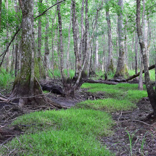
# 23 - Cooks Creek Valley
Rated: Moderate
7.2 miles, round-trip, out-and-back hike
Part of the Francis Marion National Forest's
Jericho Horse Trail, this interesting trek
takes the family hiker from Yellow Jacket Rd.
to Hell Hole Rd. Most of the hike follows the
wide Cooks Creek Valley. The trail is a mix
of pine forest and some bottomland/swamp
habitat around the Forest Rd. 165 area. Take
your time and look around. You'll discover lush,
-green valleys, wildflowers in spring and summer,
-and a pretty little pond with water lilies. This
-hiking route has a lot of variety in every season.

Allowed
on leash

No
.jpg)
Difficulty: Moderate, but only due to distance.
Distance: 7.2 miles, round-trip, out-and-back hike.
Time: 2.5 - 3.5 hours.
Trail Surface: Dirt and pine covered, forest service road, some wet/muddy areas.
Stroller Friendly: No.
Trail Marker: Blue blazes on trees, and good signage on the trail.
Jericho Horse Trail Map: Click HERE (this route follows trail between FR 158 and FR 159).
Crowds: Light.
Fees/Permits: None.
Precautions: Biting insects can be formidable in the warmer months. Bring insect repellent. This area is wet
nearly year-round. You might get your shoes wet/muddy. IMPORTANT: Hikers must yield to horseback
riders. Step off the trail and stop!
It's advised to wear "hunter's orange" or other bright colored clothing during hunting season.
Yellow Jacket Rd. Trailhead / Beginning of Hike: Yellow Jacket Rd., Huger, SC 29450. GPS: 33.162100, -79.753267
or 33°09'43.6"N 79°45'11.8"W. Note: the GPS coordinates are the best find to locate the trailhead.
Hell Hole Rd. Trailhead / End of Hiking Route / Turn-Around Point: Hell Hole Rd., Huger, SC 29450.
GPS: 33.186617, -79.753133 or 33°11'11.8"N 79°45'11.3"W.
Contacts: Francis Marion National Forest 843-336-2200.
So Much History Nearby: Did you know Berkeley County has more than 110 historical markers and historical points of interest? CLICK HERE to find your Adventures in History!
Weather on the Trail: Click HERE
.jpg)


