# 24 - The Hatchery Flats
Rated: Easy
5 miles, round-trip, out-and-back walk
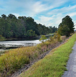
Hike atop a flat and easy, well-maintained
water impoundment with gorgeous views of
west Lake Moultrie. This adventure has
miles blooming aquatic plants in the warmer
months, a guarantee to see large birds
(egrets, herons, osprey and bald eagle are
-common sights!), and impressive panoramic
views of the lake. On this trek, you'll parallel
a quiet, narrow scenic waterway that acts as-
-a buffer to the larger Hatchery Waterfowl Area.-.

Allowed
on leash

Yes*

Difficulty: Moderate, but only due to distance.
Distance: 5 miles, round-trip, out-and-back hike.
Time: 1.5 - 2 hours.
Trail Surface: Service road; small gravel, dirt.
Stroller Friendly: Yes; with large-wheeled, all terrain strollers.
Trail Marker: None, but this trail is very easy to follow.
Crowds: Very light; you're not likely to see many others.
Fees/Permits: None.
Restrooms: None.
Precautions: There is no protection from the sun on the dike. A wide brim hat and sunscreen are
recommended. Biting insects can be formidable in warmer months. Bring insect repellent.
Where to Park: Hatchery Waterfowl Management Area, State Road S-8-802, Pinopolis, SC 29469.
Where to Start Your Walk: Approximately 330 ft. before (southwest) of the parking area is a dirt road that crosses
over the road that you drove in on. You'll begin on the dirt road, heading southeast.
GPS for where you'll begin walk: 33.267806, -80.105472 or 33°16'04.1"N 80°06'19.7"W.
Alternative Place to Park & Start Walk: Approximately 3.8 miles northwest from The Hatchery on HWY-6 is another
gate to access the dirt road that makes up this walkway. This is the far western terminus of the dirt road. It's 300-ft.
before HWY-6 intersects with Ranger Drive. GPS: 33.281722, -80.168417 or 33°16'54.2"N 80°10'06.3"W.
Contact: Santee Cooper 843-761-4068.
So Much History Nearby: Did you know Berkeley County has more than 110 historical markers and historical points of interest? CLICK HERE to find your Adventures in History!
Weather on the Trail: Click HERE
.jpg)


